Subjects
Grades
Ocean circulation is the movement of all ocean water on a planetary scale.
An ocean current is the continuous predictable movement of an oceanic water mass.
The main types of ocean currents are surface currents and deep currents. Together, some surface currents and deep currents form the thermohaline circulation: a massive loop that runs continuously through all of the Earth's oceans.
Surface currents are ocean currents that carry water in approximately the top |400\ \text{m}| layer of the ocean.
The following image shows the main surface currents around the planet.
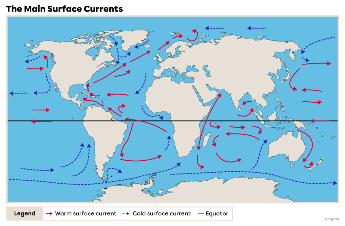
Surface currents regulate local climates by transporting warm and cold surface water in fairly consistent patterns.
The Gulf Stream and the North Atlantic drift tend to warm up the climate around the western parts of Europe. These surface currents bring warm water from the Gulf of Mexico and the Caribbean Sea to the higher latitudes. This allows many countries in the north-western part of Europe, such as France, Ireland, Iceland, United Kingdom and Norway, to experience a milder climate than the north-east of Canada which is located at similar latitudes.
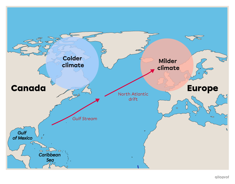
The effect of the Gulf Stream and the North Atlantic Drift on the climate of northwest Europe
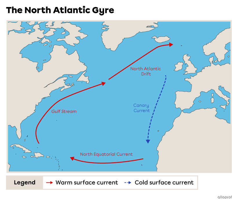
Some surface currents tend to form vast whirlpools called gyres. The following image shows the five main gyres around the planet.

The Gulf Stream, the North Atlantic Drift, the Canary Current and the North Equatorial Current are surface currents that form the North Atlantic Gyre.
Surface currents are mainly influenced by winds and the Earth's rotation around its own axis.
Winds blowing over the surface of the oceans transfer some of their mechanical energy to the water masses. As a result, the most superficial layer of water in the oceans is pulled in a similar direction to the winds.
This effect becomes less intense the deeper the water is. Approximately the top |400\ \text{m}| of water experiences the effect of winds.
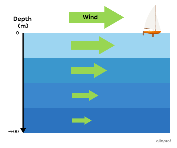
The effect of wind on surface currents
The rotation of the Earth around its own axis causes surface currents to deviate from their course. This phenomenon is called the Coriolis effect and is due to the motion of the currents relative to the Earth, which is itself in motion.
The following images show the straight-line motion of an object on a disc at rest and on a rotating disc.
On the disc at rest, the object moves in a straight line on the yellow portion of the disc.
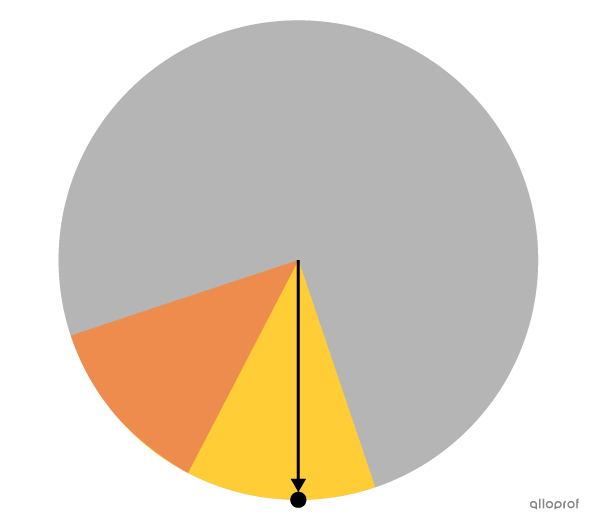
The motion of a marble on a disc at rest
On the rotating disc, the object moves in the same straight line, but its trajectory now ends on the orange portion of the disc. The path of the object on the rotating disc is therefore deviated.
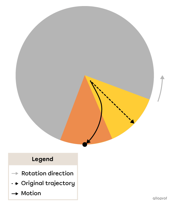
The motion of a marble on a rotating disc
The surface currents are deflected because they are subject to the Coriolis effect. Currents flowing from the equator towards the poles are deflected to the east. In contrast, currents flowing from the poles towards the equator are deflected towards the west. Currents that are directly aligned with the equator are generally not deflected.
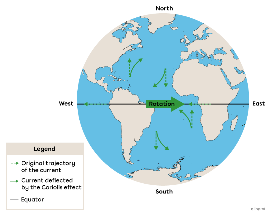
The Coriolis effect on surface currents
The prevailing winds are also subject to the Coriolis effect. Their deflection is similar to that of the surface currents.
Deep currents, also known as subsurface currents, are ocean currents that move ocean water at the depth of |400\ \text{m}| and deeper.
The variation in the density of ocean water is responsible for the formation of deep ocean currents.
The main factors influencing density are temperature and salinity.
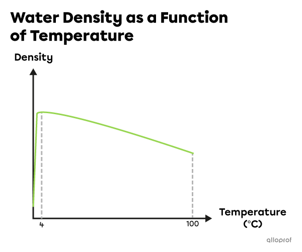
At temperatures above |4^\circ\text{C},| the density of water decreases as its temperature increases.
The temperature of water varies with depth, season and latitude, as shown in the following table:
|
Cold water |
Warm water |
|---|---|
|
Great depth |
Shallow depth |
The density of water increases when its salinity increases.
The amount of precipitation, evaporation and melting of glaciers, as well as melting and formation of pack ice or ice floes, influence the salinity of water. Water tends to be more or less salty under the following conditions:
|
Low-salinity water |
High-salinity water |
|---|---|
|
High precipitation |
Low precipitation |
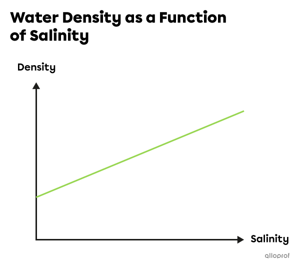
Cold high-salinity water has a higher density than warm low-salinity water.
The deep currents begin in the polar regions, where the intensity of solar radiation is relatively low. In addition, the air masses above the water are very cold. As the polar ocean waters transfer their thermal energy to the atmosphere, they cool down. Under these conditions, the surface water freezes and pack ice or ice floes form.
During its formation, pack ice releases salt into the water. The already cold polar water also becomes very salty.
The combination of decreasing temperature and increasing salinity causes the density of the water to increase and it sinks to the depths.
The very dense water from the poles flows deep in the ocean.
On their way, the water masses collide with other deep currents or land formations on the ocean floor.
When there is a collision, the water masses tend to rise to the surface.
The water mixes with the warmer and less salty surface water.
This water is then dragged back towards the poles, where the cycle repeats.

The formation of deep currents
Together, some surface and deep currents form the thermohaline circulation. It is responsible for distributing heat around the planet.
The thermohaline circulation is a predominantly deep-sea current that flows through the planet’s oceans and forms a continuous loop, often called the global conveyor belt.
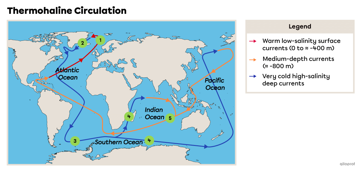
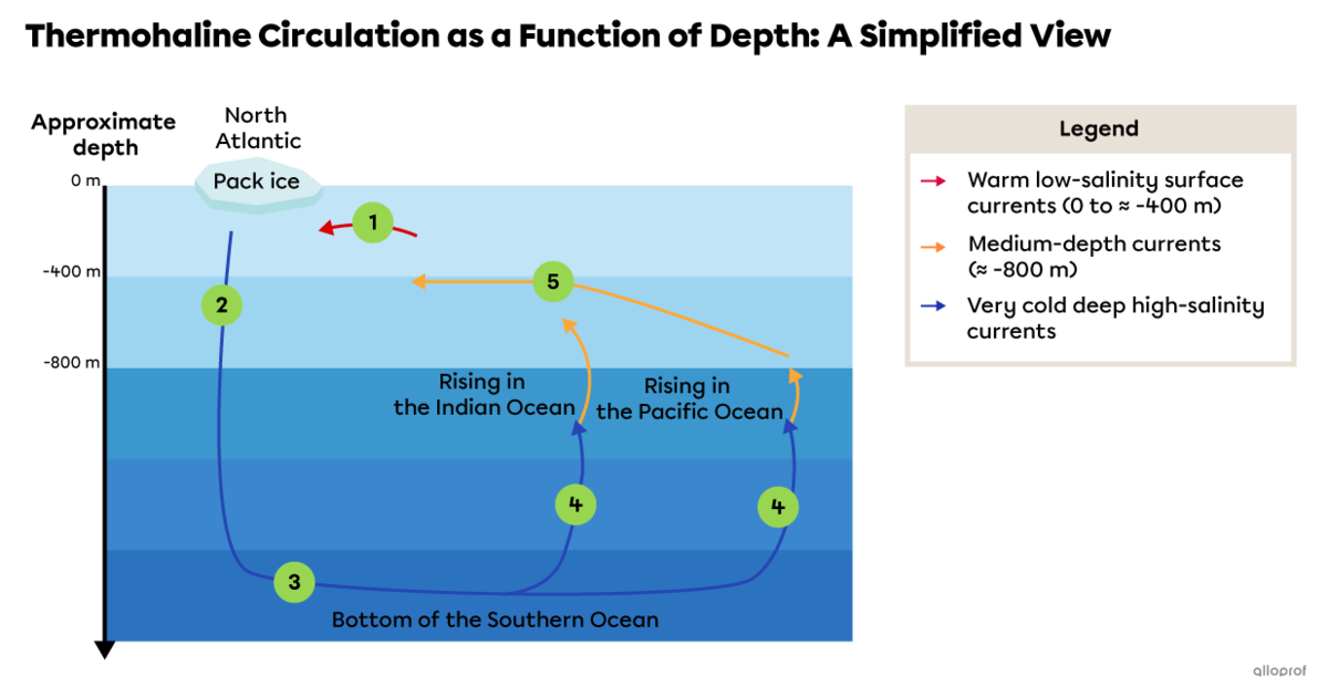
The term thermohaline refers to the temperature (thermo-) and salinity (-haline) of the water. The following images describe the path of the thermohaline circulation.
Warm surface water from the Gulf of Mexico and the Caribbean Sea reaches the North Atlantic near the coast of Iceland.
The decrease in temperature and increase in salinity makes the water denser and causes it to sink deeper in the ocean.
At great depth, the water moves towards the South Pole to reach the depths of the Southern Ocean, also known as the Antarctic Ocean.
There, the thermohaline circulation splits into two loops, one going to the Indian Ocean and the other to the Pacific Ocean, where the water will rise towards the surface without reaching it (never higher than |-800\ \text{m}|). The water will warm up a little and its salinity will decrease.
The loops of the Indian Ocean and Pacific Ocean join and eventually return to their starting point.
Ramade, F. (2009) Éléments d’écologie : Écologie fondamentale (4e éd.). Dunod.