Subjects
Grades
To access the other concept sheets in the Cities Subject to Natural Hazards unit, check out the See Also section.
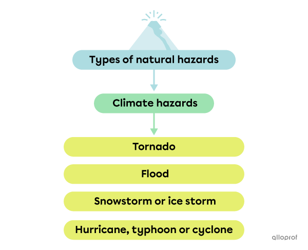
Climate hazards are natural hazards that result from climate phenomena.
A tornado is a funnel of violent winds that extends from the base of a cloud to the ground.
Tornadoes are difficult to predict, move quickly and their trajectory is totally unpredictable. With winds clocking up to 500 km/h, tornadoes can uproot trees, roll cars and destroy houses. They sometimes also bring heavy rain and hail and present a serious risk to the lives of those in their path.
Tornadoes more often occur in the USA and in Canada than anywhere else.
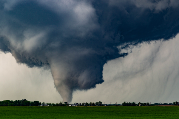
Tornado in the State of Iowa, in the United States
In 1971, Dr. Ted Fujita invented the Fujita Scale to categorize tornadoes based on an estimation of their wind speed and the damage caused. In early 2002, scientists realized there were deficiencies in the original scale and developed the Enhanced Fujita Scale. This scale has been used in the United States since 2007, and in Canada since 2013.
| Category | Wind speed | Possible damage |
|---|---|---|
|
F0 |
104 to 137 km/h |
|
|
F1 |
138 to 177 km/h |
|
|
F2 |
178 to 217 km/h |
|
|
F3 |
218 to 266 km/h |
|
|
F4 |
267 to 322 km/h |
|
|
F5 |
322 km/h and over |
|
Source of the data: The Weather Channel, 2020[12]. |
||
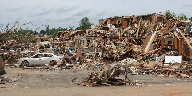
Photograph of the Destruction Caused by an F4 Tornado That Touched Down in the City of Tuscaloosa, Alabama, in the United States.
The Enhanced Fujita Scale is used in Canada but has been modified so that it is better adapted to the country’s reality. To find out more, check out the page Enhanced Fujita scale for wind damage.
A flood occurs when a large quantity of water occupies a territory that is usually dry.
Floods are the most common climate-related natural disasters. They can occur in a few minutes or hours, and can last up to weeks.
A flood can be caused by different factors:
heavy rainfall
rapid snow melt
a storm surge that accompanies cyclones, typhoons and hurricanes
The most dangerous types of floods are flash floods. They occur when a very large quantity of rain falls in a short period of time and the soil does not have the capacity to absorb all the water. They are often quite serious and occur in a matter of minutes. Flash floods take people and authorities by surprise, which is what makes them dangerous.
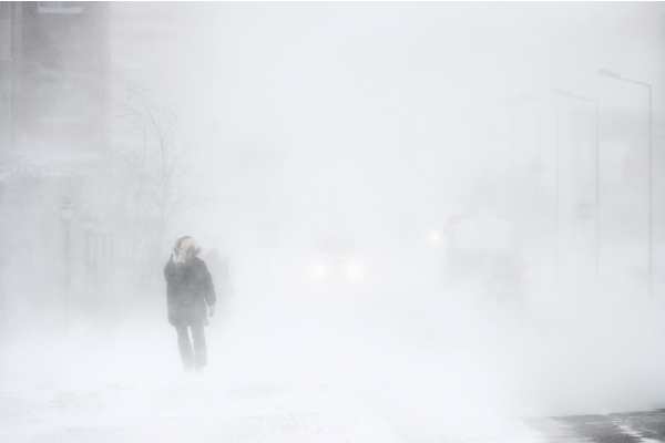
Winter storms occur anywhere in the world that has a cold, continental or temperate climate. It can take three different forms:
A snowstorm can completely paralyze a city for a few hours or even a few days. The accumulation of snow can make travel difficult, or even dangerous and impossible. A snowstorm’s impact depends on its location. For example, regions that generally receive a lot of snow have measures in place to quickly remove it from streets and sidewalks.
Extreme cold can occur during the winter and is also dangerous for those who are not used to it. Cold warnings are adapted to the climate of each region. In Quebec, an extreme cold warning is issued when the temperature drops to -38°C for at least two hours, while in Ontario, an extreme cold warning is issued when the temperature is expected to fall to -30°C[8].
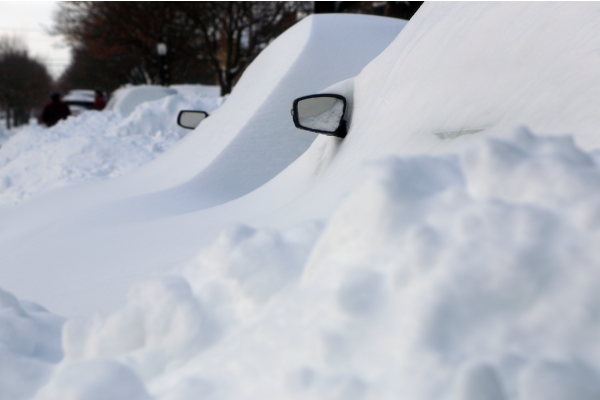
Cars Covered in Snow After a Storm in Montreal
In Quebec, an average of 275 cm of snow falls in the winter, however, the quantity varies from region to region. In Montreal, the average is 175 cm of snow, while in Quebec City, it is 300 cm. The Laurentians get more than 600 cm of snow in the winter[7]. For Quebec, the Meteorological Service of Canada sends a heavy snow warning only when more than 15 cm of snow is expected in 12 hours or less. Planning and preparing snow-removal operations allows people to go about their daily routines.
Inversely, places that are not used to getting snow or that get very little, like Washington and Atlanta, in the United States, or even Vancouver, Canada, are paralyzed by a few centimetres of snow.
To find out more, check out the following article.
A blizzard ressembles a snowstorm, but is accompanied by high winds, which leads to low visibility.
According to the Meteorological Service of Canada (MSC), a blizzard is a snowstorm that lasts at least six hours, with wind speeds of more than 40 km/h. These strong winds lead to drifting snow, which can reduce visibility to less than one kilometre[5].
Like all winter snowstorms, blizzards occur in places where the temperature drops to below zero. In Canada, blizzards are most common in the Prairies and the Maritimes.
Blizzard in Siberia
Drifting snow is fine snow that is lifted and carried by the wind.
An ice storm occurs when there is freezing rain, which is a form of rain that freezes instantly when it comes into contact with the ground or an object. The layer of ice formed is called glaze or sheet ice.
Freezing rain is fairly difficult to predict. It is dreaded because the layer of ice can make surfaces extremely slippery, slowing down traffic and causing major accidents. Sidewalks also become very dangerous for pedestrians. The weight of the ice can damage electrical lines, tree branches, and so on.
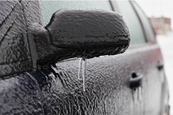
A Layer of Glazed Ice After Freezing Rain
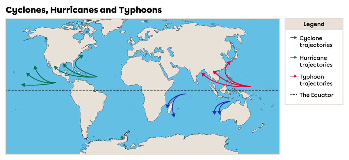
Hurricane, typhoon and cyclone are different names given to the same meteorological phenomenon. The name changes depending on where the storms occur.
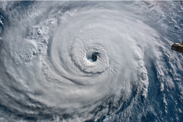
Hurricane Florence Above the Atlantic Near the U.S. Coast
A cyclone is a violent storm that originates in the oceans close to the Equator. It can also be referred to as a typhoon or a hurricane depending on the region where it forms.
Cyclones, hurricanes and typhoons are violent storms characterized by strong winds and lots of rain. They form in the ocean close to the equator, meaning between the 30th parallel north and 30th parallel south. The temperature must be fairly high to lead to the formation of a storm. Their trajectory varies according to meteorological conditions. Some storms stay in the ocean, while others hit certain islands as well as the coasts of continents. In general, scientists are able to estimate the trajectories of these storms.
When these storms hit coastal areas, they can cause enormous damage. Strong winds, heavy precipitation and waves can cause floods, flatten buildings, damage electrical lines and much more. In areas where the population is not adequately prepared, these storms can also lead to many deaths.
| Hurricane | Cyclone | Typhoon | |
|---|---|---|---|
| Location | Atlantic Ocean and in part of the Pacific Ocean | Indian Ocean and the southern Pacific Ocean | Northwestern Pacific Ocean |
| Period | June to December | April to December | End of June to December |
Scientists and meteorologists use the Saffir-Simpson Scale to categorize these storms. Hurricanes, typhoons and cyclones are rated from 1 to 5, mostly based on wind strength.
When winds are below 63 km/h, it’s considered to be a tropical depression. This becomes a tropical storm when the winds are between 63 and 118 km/h. According to the World Meteorological Organization, these storms become hurricanes, typhoons or cyclones when the winds reach 119 km/h or higher[6].
| Category | Wind speed | Description of Damage |
|---|---|---|
|
1 |
119 to 153 km/h |
|
|
2 |
154 to 177 km/h |
|
|
3 |
178 to 208 km/h |
|
|
4 |
209 to 251 km/h |
|
|
5 |
252 km/h or higher |
|
Source: National Hurricane Center, n.d.[11] |
||
To access the rest of the unit, you can consult the following concept sheets.